Route 1 Bike:
Melero y Sierra del Cordón
If you want to see larger images, click on them
Tipe: Circular
Distance: 34,5 km.
Strech of path: 26,2 km.
Strech of road: 8,3 km.
Time: About 2 hours
Highest point/lowest point:
655/397 meters
Difficulty: Low
Time: All year round
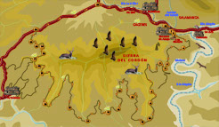
Route summary: The route begins and finish in Riomalo CTR, surrounding the Sierra del Cordón. Shortly after the beginning, it leaves asphalt and reaches the Mirador de la Antigua and the marvellous meander of Alagón river, Melero. Later the path turns again and again, following the contour lines, while it goes along with the river in its way towards the reservoir of Gabriel and Galán. The route changes the Alagón river by the course of the Hurdano towards Arrolobos, a small village that crosses another of our routes. Then the itinerary looks for the main road of Las Hurdes, in order to finish in Riomalo CTR, a few kilometers later.
The route offers beautiful panoramic views of the course of Alagón river, Arca and Buitrera (Natural Park of Las Batuecas - Sierra de Francia) and the reservoir of Gabriel y Galán.
Information: Download the booklet of the route, in pdf file, the roadbook or the files in format .kmz, .html by clicking on the appropriate button.
If you want the .gpx file, please, visit our web for PC.
Use the buttons to move along the routes.


