Route 2 Bike:
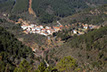
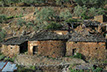
Valle del Ladrillar


<
>
4 - 4
Cerrar
If you want to see larger images, click on them
Tipe: Circular
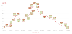
Distance: 50,9 km.
Strech of path: 18,6 km.
Strech of asphalt: 32,3 km.
Time: Between 4 y 5 horas
Highest point/lowest point:
655/397 meters
Difficulty: High (by the strong uneveness)
Time: All year round
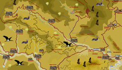
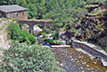
Route summary: The route begins in Riomalo CTR. After a few kilometers of road, it takes a path and goes up the Sierra del Cordón over the Ladrillar river: The itinerary returns to enter road near Riomalo de Arriba, "alquería" over which the river is born, in the hills that enclose it to the North. The panoramic become huge over the Sierra de las Mestas, the valley and its "alquerías". The road descends alongside de Ladrillar river, crossing small villages that over time have seen and suffered the rush of the Río Malo (Bad River or Ladrillar), whose waters have broken with force the verticality of its course in the rainy season, from Riomalo de Arriba to Riomalo de Abajo.
Information: Download the booklet of the route, in pdf file, the roadbook or the files in format .kmz, .html by clicking on the appropriate button.
If you want the .gpx file, please, visit our web for PC.
Use the buttons to move along the routes.