Route 3 Bike:
Valle del Malvellido y
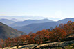
Sierra de la Corredera


<
>
4 - 4
Cerrar
If you want to see larger images, click on them
Tipe: Circular
Distance: 75 km.
Strech of path: 40 km.
Strech of asphalt: 35 km.
Time: About 8 hours
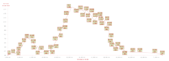
Highest point/lowest point: 1.366/397 meters
Difficulty: High (by the strong uneveness and the length of the route)
Time: All year round, except the months of December and January, because the path may be icy or snow in the highest area
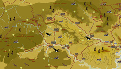
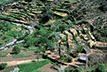
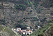
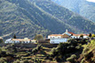
Route summary: The route begins in Riomalo CTR and leaves the road after some kilometers to take the path over the valley of Ladrillar towards El Collado de los Ladrones, from where it changes the valley of the Ladrillar by the valley of the Hurdano. Then the route goes down a path and reaches Rubiaco y Nuñomoral, two beautiful villages that stretch along the Hurdano river. Then our itinerary goes into the valley of the Malvellido river and begins the climbing to the impressive Sierra de la Corredera, which will skirt almost touching its highest summits. From the same path good prospects of some of the most iconic and remote villages of Las Hurdes will be obtained: El Gasco, Fragosa, Martilandrán... At the end of the descent, the little dam of Cerezal and the Malvellido river. Some kilometers of asphalt and the route will returns to Romalo CTR.
Information: Download the booklet of the route, in pdf file, the roadbook or the files in format .kmz, .html by clicking on the appropriate button.
If you want the .gpx file, please, visit our web for PC.
Use the buttons to move along the routes.