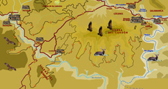
Route 4 Bike:
Valles del Hurdano y Alagón y
Sierra del Romero


<
>
1 - 4
Cerrar
If you want to see larger images, click on them
Tipe: Circular
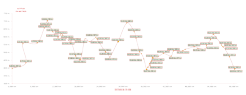
Distance: 60 km.
Strech of path: 48 km.
Strech of asphalt: 12 km.
Time: About 6 hours
Highest point/lowest point: 702/392 meters
Difficulty: High (by the length of the route)
Time: All year round
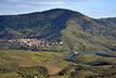
Route summary: The present route approaches some of the most emblematic places in the surrounding of Riomalo de Abajo. Between them, la Sierra del Cordón, la del Romero, los valles del Hurdano y del Alagón.
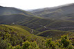
During all way, the landscapes will be opened endless over the horizon of mountains and valleys of the south-east region of Las Hurdes, extending towards La Pesga and the mountains of the same name, towards the reservoir of Gabriel y Galán and the southern foothills of the Natural Park de las Batuecas - Peña de Francia, in the area known as Arca y Buitrera.
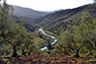
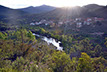
And finally, nothing better than coming back to admire El Melero , the wonderful meander of Alagón river, from the Mirador de la Antigua.
Information: Download the booklet of the route, in pdf file, the roadbook or the files in format .kmz, .html by clicking on the appropriate button.
If you want the .gpx file, please, visit our web for PC.
Use the buttons to move along the routes.