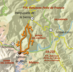
Route 2: Valle del Cabril. Fuente el Águila y Fuente Mundo


<
>
1 - 4
Cerrar
If you want to see larger images, click on them
Tipe: Circular
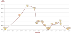
Distance: 10,56 km.
Time: About 5 hours
Highest point/lowest point: 649/387 meters
Difficulty: High (for the altitude that it saves and the narrow of the path in some section )
Recommended season: All year round
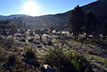
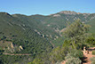
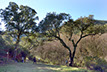
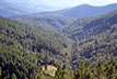
Route summary: The route goes up the slopes of the Sierra del Castillo, from Riomalo de Abajo to almost Herguijuela de la Sierra, and returns along the brook of Cabril by the path that the carriers formerly used to carry and collect products of Las Hurdes. The trail, since the beginning, goes into lands of the Natural Park of Las Batuecas-Sierra de France, and all of it virtually walks through the protected area. The way up opens wide views over mountains and valleys, showing an impressive nature.
Information: Download the leaflet of the route, in pdf file or in format .kmz, .html o .gpx, by clicking on the appropriate button. If you need the .gpx file, remember you can download it from the web of Riomalo for PC.
Use the buttons to move along the routes.