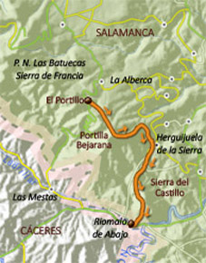
Route 3: Portillo Batuecas - Riomalo. Risco de los Altares
y Torrita


<
>
1 - 4
Cerrar
If you want to see larger images, click on them
Tipe: Linear
Distance: 15,6 km.
Time: About 7 hours
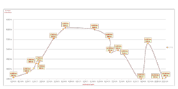
Highest point/lowest point:
1.296/397 meters (almost the entire way is down)
Difficulty: High (for the narrow of the path in some zones; the weather can complicate the route, even the rain or the snow can do it)
Recommended season: All year round, if the weather is not adverse
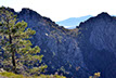
Route Summary: The path surrounds some of the highest peaks of the Natural Park of the Sierra de France Batuecas . It begins in the Portillo de las Batuecas, it reaches the Portilla Bejarana , then it changes the slope and goes down almost Herguijuela de la Sierra. The final zone surrounds the Sierra del Castillo and follows the course of the Cabril, goes to the Fuente EL Águila and ends in Riomalo de Abajo.
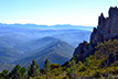
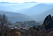
The route overlooks the incredible scenery of Las Batuecas , La Sierra de Francia, La Sierra de Béjar and del Castillo, adding the chance to know " La Torrita", a millennial has, the remains of the Monasterio of Belén and the urban whole of Herguijuela de la Sierra.
Information: Download the leaflet of the route, in pdf file or in format .kmz, .html o .gpx, by clicking on the appropriate button. If you need the .gpx file, remember you can download it from the web of Riomalo for PC.
Use the buttons to move along the routes.